Space Weather Workshop Agenda w/Abstracts
Schedule 2017
Monday: May 1
|
|
|
2:00 - 4:30 pm |
Electron Sensor Intercalibration Workshop
Alder Boardroom
The electron sensor intercalibration workshop will be an opportunity to give informal presentations and have discussions on recent efforts to intercalibrate electron measurements and challenges encountered. Calibration activities with NOAA's GOES satellites, JMA's Himawari-8 satellite, and European Space Agency satellites are among those that will be discussed. The challenge of converting limited measurements to energy and pitch angle spectra for use in numerical models will also be discussed. If you plan to participate, please contact Elsayed Talaat (elsayed.r.talaat@nasa.gov) and Terry Onsager (terry.onsager@noaa.gov).
|
|
1:30 - 4:30 |
R2O2R (Research to Operations to Research) Open Community Meeting Fir Boardroom
In August 2016, a meeting was held in Boulder, CO to discuss Research to Operations (R2O) and Operations to Research (O2R) and to gather input for agencies to respond to the National Space Weather Action Plan’s request for a plan for the improvement of operational space weather forecasting. Since then, a plan was developed and posted to the Federal Register for public comment. Those comments are being addressed. Now, with people gathering for the Space Weather Workshop, we have an opportunity to continue the discussion to help define the R2O2R process and options for a center/capability that can meet the Nation’s space weather needs. We invite your participation at this meeting. |
|
3:00 - 4:30 |
Student Workshop |
|
5:00 - 7:00 pm |
Welcome Networking Session |
Tuesday: May 2 |
|
|
8:30 am |
Conference Welcome |
|
8:40 - 10:00 |
Space Weather Workshop 2017 Kickoff |
|
8:40 |
Challenges of Forecasting Space Weather Storms |
|
9:00 |
Review of U.S. Government Space Weather Policies Since 1994, components of the U.S. Government have been developing policies to enhance space weather research, forecasting, and preparedness. These efforts stem from agency, executive, and legislative actions. Recently, there has been a flurry of activity on space weather policy driven by a number of congressional and executive actions. This talk will review recent policies and discuss a framework to categorize significant U.S. space weather policies. |
|
9:20 |
Political Perspectives Annie Larson, Regional Director- Denver Office of Senator Cory Gardner |
|
9:40 |
ESA SSA Space Weather System Networking of European Space Weather capabilities has reached a major milestone in spring 2017, when new capabilities from ESA’s Space Weather (SWE) Network consisting of the SSA SWE Coordination Centre (SSCC) and the five Expert Service Centres (Solar Weather, Heliospheric Weather, Space Radiation, Ionospheric Weather and Geomagnetic Conditions) have been deployed and made available to the end users. This deployment brings the total number of space weather products from the network to over 115 and the services available to the end users to 17. These achievements together with the mandate and funding given by the ESA Member States to the ESA’s SSA Programme in the Ministerial Council in December 2016 are putting the Programme in an excellent position to start transitioning the SWE Networks towards the SSA Space Weather System. The strategic objectives for the Space Weather System development for 2017-2019 have been defined as:
The means to achieve these objectives will include verification and validation of the products and services from the system, enhancement of services to key user domains, establishment of a robust R2O process, consolidation of the interfaces to ground based SWE measurements and development of operational European space based SWE measurement capability. As part of this work, ESA will continue the development of a space weather monitoring mission to L5. This presentation will cover the current status of the ESA’s SSA Space Weather Network, the current service capabilities and the next steps for transitioning it into a Space Weather System. The presentation will address ESA’s plans for implementing a space based SWE monitoring system including the mission to L5 and considerations for international collaboration for maintaining space weather observation capability in a sustainable way. |
|
10:00 - 11:00 |
Poster Session & Break (Solar and Interplanetary Research and Applications) |
|
11:00 - 12:30 pm |
Economic Impacts |
|
11:00 |
Disaster Impact Assessment Methods for Space Weather Critical Infrastructure Failure: Input-Output Approaches and Beyond Increasing focus is being placed on the socioeconomic impacts of space weather, leading to a flurry of studies attempting to make progress on this under-researched area. In this presentation, the current state-of-the-art in disaster impact assessment is reviewed, including the key methods for quantifying potential economic disruption due to critical infrastructure failure from space weather events. An overview of the fundamentals of the input-output economics method is then carried out, with the aim of providing more methodological understanding of this approach for the space weather community. Finally, a comparative evaluation is undertaken on the key advantages and disadvantages of the different approaches available for space weather impact assessment, with insight into how they may provide diverging results. Effective ex ante and ex post disaster impact assessment methods are ultimately key tools which can help to manage the risks posed by global threats such as extreme space weather. |
|
11:15 |
The Social and Economic Impacts of Space Weather (U.S. Study) The National Space Weather Action Plan calls for new research into the social and economic impacts of space weather and for the development of quantitative estimates of potential costs. In response to this call, NOAA’s Space Weather Prediction Center (SWPC) and Abt Associates are working together to identify, describe, and quantify the impacts to U.S. interests within four sectors including the electric power grid, commercial aviation, satellites, and GPS users. Our comprehensive study covers the following five broad impact categories: costs of defensive investments, mitigating actions, asset damage, service interruptions, and health effects. This study began with an extensive literature review of existing science and economic assessments, which was then refined and enriched with findings from stakeholder outreach. This outreach spanning engineers, operators, and researchers across the four sectors provided insight on the relative importance and future trends of sector impacts, how different stakeholders use SWPC products to lessen these costs, and specific examples and details to inform our modeling effort. Our team is currently building Excel-based tools for estimating potential costs, which consist of simple but transparent models that mechanistically simulate how moderate and extreme space weather events impact these four sectors. This work will also describe how these models can be used to better understand the value of space weather information provided by SWPC products and services. This presentation will provide an overview of our work to date as well as lessons learned, key questions, and next steps in our study. |
|
11:30 |
ESA Juha-Pekka Luntama, European Space Agency (ESA) |
|
11:45 |
Quantifying the Daily Economic Impact of Extreme Space Weather Due to Failure in Electricity Transmission Infrastructure Extreme space weather due to coronal mass ejections has the potential to cause considerable disruption to the global economy by damaging the transformers required to operate electricity transmission infrastructure. However, expert opinion is split between the potential outcome being one of a temporary regional blackout and of a more prolonged event. The temporary blackout scenario proposed by some is expected to last the length of the disturbance, with normal operations resuming after a couple of days. On the other hand, others have predicted widespread equipment damage with blackout scenarios lasting months. In this paper we explore the potential costs associated with failure in the electricity transmission infrastructure in the U.S. due to extreme space weather, focusing on daily economic loss. This provides insight into the direct and indirect economic consequences of how an extreme space weather event may affect domestic production, as well as other nations, via supply chain linkages. By exploring the sensitivity of the blackout zone, we show that on average the direct economic cost incurred from disruption to electricity represents only 49% of the total potential macroeconomic cost. Therefore, if indirect supply chain costs are not considered when undertaking cost-benefit analysis of space weather forecasting and mitigation investment, the total potential macroeconomic cost is not correctly represented. The paper contributes to our understanding of the economic impact of space weather, as well as making a number of key methodological contributions relevant for future work. Further economic impact assessment of this threat must consider multiday, multiregional events. |
|
12:00 - 12:30 pm |
Panel Discussion |
|
2:00 - 3:40 |
Executive and Congressional Space Weather Activities |
|
2:00 |
DOD R2O Perspectives |
|
2:15 |
Update on SWORM/ SWAP and R2O |
|
2:30 |
NASA Perspective on R2O |
|
2:45 |
DHS and Space Weather |
|
3:00 |
NSF Perspective on R2O |
|
3:15 - 3:40 |
Panel Discussion |
|
3:40 - 4:30 |
Poster Session & Break (Solar and Interplanetary Research and Applications) |
|
4:30 - 5:50 pm |
Broader Space Weather Community Perspectives |
|
4:30 |
Architecting the Future to Meet the Nation’s Space Weather Needs The U.S. federal government today presses its agencies to assess space weather capabilities and readiness. It has become apparent that the nation will benefit from an organization that merges the strengths of operational and scientific research, engineering, planning and preparedness, and public outreach to meet the long-term objectives of the National Space Weather Strategy and Space Weather Action Plan. This will improve our collective readiness to predict and respond to space weather threats in key and crucial ways. The University of Colorado (CU) Boulder and its Laboratory for Atmospheric and Space Physics (LASP), Department of Aerospace Engineering Sciences, and Cooperative Institute for Research in the Environmental Sciences (CIRES) have been collaborating with many of our nation’s top space weather practitioners to envision an organization and associated architectures that will meet these objectives. This work will allow progress toward clearly defined and measureable improvements in space weather public awareness and protection. This presentation lays out elements of an approach that can form a basis for cooperation between academia, industry, and government to carry forward the efforts that have energized the space weather community over the past decade. |
|
4:50 |
"The Space Weather Development Center: A Proposed Space Weather Community Model Solution"
Dan Welling, University of Michigan
|
|
5:10 |
R2O: A Commercial Perspective |
|
5:30 |
End of Session |
|
5:45 - 8:00 pm |
11th Annual NOAA/ SWPC - Commercial Space Weather Interest Group (CSWIG)/American Commercial Space Weather Association (ACSWA) Summit Meeting – by invitation |
Wednesday: May 3
|
|
|
8:30 - 8:40 am |
Space Weather Morning Forecast Shawn Dahl, NOAA/SWPC Space Weather Forecasting Office |
|
8:40 - 9:55 |
Session: R2O Challenges and Successes |
| 8:40 |
NASA LWS and R2O |
|
8:55 |
The Air Force Research Laboratory and Space Weather R2O The Air Force Research Laboratory (AFRL) houses the US Air Force’s space environmental science and technology (S&T) activities addressing defense requirements. The Laboratory executes a relatively small in-house and contract research effort spanning basic and applied research, and advanced technology development, focused on knowledge and technology gaps affecting the joint force. The service Laboratory’s most critical role is to provide the bridge between the joint warfighter and the space weather research community, both to translate operational gaps into research needs and to translate research outcomes into tailored operational technologies. This is accomplished by understanding today’s military operations and technologies, identifying (and often anticipating) space environmental capability gaps, formulating required S&T, and engaging our in-house experts with the greater research community to achieve those goals. AFRL then conducts demonstration and prototyping activities to buy down risk, feed outstanding requirements back to the research activities, and shepherd new capabilities into operations in partnership with the DoD product centers and our sister laboratory. As the DoD operating environment continues to evolve and the impacts of space weather on civilian activities gains recognition, it is clear that closer partnership between the military and civil sides of the enterprise (including commercial and allied) is increasingly critical for creating and sustaining the required observational, modeling and exploitation infrastructure in a cost-effective manner. |
|
9:10 |
Commercial R2O2R Activities |
|
9:25 |
NOAA/SWPC R2O Activities The past 5 years has seen Space Weather Prediction Center (SWPC) undergoing a number of projects to transition large-scale space weather computer models into operational use on the National Weather Service (NWS) supercomputers. The models have addressed forecasting the Solar wind at Earth, 5 days into the future (WSA-Enlil), with particular attention to predicting the arrival of Coronal Mass Ejections (CMEs) and, more recently, shorter time scale predictions of the Geospace environment, driven by direct measurements of the Solar Wind at L1 (DSCOVR) and utilizing a magnetospheric model developed at the University of Michigan (SWMF). Most recently we have undertaken the transition of a whole-atmosphere/ionosphere model (WAM-IPE), an extension of the NWS Global Forecasting System (GFS), to provide a 3 day forecast of ionospheric changes driven by both space weather conditions and also by the day-to-day variability in the forcing from the lower atmosphere. My talk will review all of these R2O activities and discuss the various model upgrades that are planned for the near future. |
| 9:40 |
CCMC LWS R2O |
|
9:55 - 11:00 |
Poster Session & Break (Ionosphere Research and Applications / General Space Weather Services and Education) |
|
11:00 - 12:20 pm |
R2O - The End User (O) Perspective |
|
11:00 |
Space Weather Research to Ops Transition: Industry Perspective The transition of research to operations (R2O) is often a difficult process. It requires interaction among customers, space weather forecasters, and space weather research and development activities. The R2O process usually involves government, academia, and industry stakeholders further complicating the effort. An effective technology transition process is essential to delivering capabilities from the laboratory to an operational environment. This process generally requires significant change to the researcher’s original design. Live data, which is less timely and sometimes filled with errors, can crash an unsuspecting laboratory model without proper safeguards. Sharing system resources with other operational models requires good behavior on behalf of the new model. Interaction with standardized processes and other system resources requires detailed systems engineering knowledge unknown to the designers of the prototype. System security certifications and protections are often overlooked in the lab environment since the prototyping effort is generally about the science and not security. All these (and many other) concerns can force wholesale changes to the prototype software. This change may be intimidating to the prototype developer since model validation may be impacted by the changes. Managing “change” is one of the biggest hurdles in the R2O transition. This presentation provides an overview of Northrop Grumman methodologies for R2O and provides some details of numerous capabilities delivered to an operational center. |
|
11:20 |
Power Grid Impacts |
|
11:40 |
Aviation Impacts |
| 12:00 |
Railroad Impacts |
|
12:20 - 1:30 |
Lunch (No Tour) |
| 1:30 - 2:50 |
Extreme Events |
| 1:30 |
Extreme Space Weather Events: What Can Solar Magnetic Fields Tell Us? The possible societal implications of extreme space weather events make them of obvious practical interest. They are also of great interest scientifically, because they test our understanding of the fundamental physical processes involved in their creation and manifestation. By their nature, extreme events are rare, making it difficult to study them or to estimate the likely upper limits of their behavior. Extreme space weather also encompasses a very broad range of phenomena, and events may be extreme in one parameter but not in another. All such events have one thing in common: their ultimate energy source is the Sun’s magnetic field. One limiting factor to extreme space weather events is then how much magnetic energy is available to power solar eruptions. In this talk, I will discuss what we can infer about the largest possible solar eruptive events from known solar and stellar events. A focus of the talk will be on how measurements of the photospheric magnetic field can be used to bound the size of the largest possible eruptive events. |
| 1:50 |
Modeling and Understanding Extreme Space Weather Space weather-driven geomagnetically induced currents (GICs) are known to disrupt operation of man-made technological systems. Even though numerous complexities, such as ground conductivity, conductor system configuration, and other engineering details, including high-voltage power transformer design are critical for in-depth assessment of the GIC threat, the geoelectric field is the primary quantity driving GICs that can provide an indication for the potential GIC hazard. However, our knowledge of detailed spatiotemporal characteristics related to geomagnetic superstorms, which tend to produce the largest GICs, is still limited. One of the key challenges is to understand the fundamental processes that initiate the development of dynamic magnetosphere-ionosphere currents, which in turn lead to the largest surface geoelectric fields. To enhance national preparedness, it is critical that we understand these processes in order to address strategic goals highlighted in the National Space Weather Strategy and Action Plan. |
| 2:10 |
How Might the Thermosphere and Ionosphere React to an Extreme Space Weather Event? If a Carrington-type CME event of 1859 hit Earth, how might the thermosphere, ionosphere, and plasmasphere respond? To start with, the response would be dependent on how the magnetosphere reacts and channels the energy into the upper atmosphere. For now we can assume the magnetospheric convection and auroral precipitation inputs would look similar to a 2003 Halloween storm but stronger and more expanded to mid-latitude, much like what the Weimer empirical model predicts if the solar wind Bz and velocity were -60nT and 1500km/s respectively. For a Halloween-level geomagnetic storm event, the sequence of physical process in the thermosphere and ionosphere is thought to be reasonably well understood. The physics-based coupled models, however, have been designed and somewhat tuned to simulate the response to this level of event that have been observed in the last two solar cycles. For an extreme solar storm, it is unclear if the response would be a natural linear extrapolation of the response or if non-linear processes would begin to dominate. A numerical simulation has been performed with a coupled thermosphere ionosphere model to quantify the likely response to an extreme space weather event. The simulation predict the neutral atmosphere would experience horizontal winds of 1500m/s, vertical winds exceeding 150m/s, and the “top” of the thermosphere well above 1000km. Predicting the ionosphere response is somewhat more challenging because there is significant uncertainty in quantifying some of the other driver-response relationships such as the magnitude and shielding time-scale of the penetration electric field, the possible feedback to the magnetosphere, and the amount of nitric oxide production. Within the limits of uncertainty of the drivers, the magnitude of the response can be quantified and both linear and non-linear responses are predicted. |
| 2:30 |
SWAP Benchmarks on Extreme Events |
|
2:50 - 3:50 |
Poster Session & Break (Ionosphere Research and Applications / General Space Weather Services and Education) |
|
3:50 - 5:10 |
GNSS Radio Occultation and COSMIC II |
|
3:50 |
COSMIC-2/FORMOSAT Program Status Overview of COSMIC-2/FORMOSAT Program Status will be provided. Updates to the Ground System, spacecraft and instruments for COSMIC-2A readiness will be provided. Status overview of COSMIC-1 will be provided. |
|
4:10 |
GeoOptics |
|
4:30 |
Ionosphere collection capability from a 3U CubeSat GNSS-RO constellation Spire Global, Inc., is a leading player in the nanosatellite sector, and one of the first to provide commercial, low-cost GNSS-RO measurements to support critical weather data for numerical weather prediction. Spire has ambitious goals of collecting over 100,000 radio occultation profiles per day, providing robust coverage of neutral measurements over the entire planet. In addition to augmenting the global observing system with a significant amount of high quality vertical atmospheric profiles, Spire will also provide a wealth of information about the ionosphere, including total electron content (TEC) and scintillation measurements. Similar to atmospheric soundings, the magnitude of ionospheric soundings will be the first of its kind. In this talk, we show initial results of TEC measurements collected from a 3U CubeSat GNSS-RO constellation, as well as a brief look toward the future in which measuring the global ionospheric state in near real-time will become a reality. |
|
4:50 |
PlanetIQ |
|
5:10 |
End of Session |
|
6:00 - 9:00 pm |
Banquet Dinner at Omni Interlocken Ballroom Special Guest Speaker: |
Thursday: May 4
|
|
|
8:40 - 9:00 am |
Keynote: The Great Space Weather Storm of May 1967: It's role in Space Weather as We Know It Although listed as one of the most significant events of the last 80 years, the space weather storm of late May 1967 has been largely forgotten. Recent discussions have brought to light that the May 1967 storm was nearly one with ultimate societal impact, were it not for the nascent efforts of the United States Air Force in expanding its terrestrial weather monitoring-analysis-warning-prediction efforts into the realm of space weather forecasting. An initial “great” solar radio burst, which caused radio interference at frequencies between 0.01-9.0 GHz, was accompanied by near-simultaneous disruptions of dayside radio communication by intense fluxes of ionizing solar X-rays. Aspects of military control and communication were immediately challenged. Shortly thereafter a solar energetic particle event interfered with high-frequency communication in the polar cap. Subsequently, record-setting geomagnetic and ionospheric storms compounded the disruptions. I detail three aspects of the storm: The great radio burst; the solar energetic particles; and the surprising effects on upper atmospheric temperature. As noted in Knipp et al. [2016] this was one of the “Great Storms” of the 20th century, despite the lack of large, geomagnetically-induced currents. Radio disruptions like those discussed here warrant the attention of today’s radio-reliant, cellular-phone and satellite-navigation enabled world. |
|
9:00 - 10:00 |
GPS/GNSS and Space Weather I |
|
9:00 |
GPS/GNSS Systems and Space Weather Impacts |
|
9:20 |
WAAS Interference |
|
9:40 |
Commercial Perspective |
|
10:00 - 11:00 |
Poster Session & Break (Magnetosphere Research and Applications) |
|
11:00 - 12:20 pm |
GPS/GNSS and Space Weather II |
|
11:00 |
Equatorial Scintillation Impact on GNSS Precise Positioning Services Fugro provides global GNSS augmentation services for the offshore industry using a dedicated and highly redundant infrastructure. In the equatorial region where the most of offshore oil exploration activities are, due to several space weather phenomena, ionospheric plasma bubbles are created. Global Navigation Satellite System (GNSS, such as GPS, GLONASS, Beidou and Galileo) signals are diffracted and refracted when passing through the plasma bubbles and this leads to rapid fluctuations in signal intensity (Amplitude Scintillation) and phase jittering (Phase Scintillation). Ionospheric scintillations can severely degrade performance and satellite-tracking ability for GNSS positioning receivers; by causing signal power loss and increased the level of measurement noise. After a brief introduction of the Fugro GNSS services, an overview of the space weather impacts on different precise GNSS positioning service will be given. The main focus will be on the equatorial scintillation occurrence and impact on the GNSS services. We will present the statistics of scintillation occurrence over last 4 years from 2013 to 2017 especially in the Brazilian sector and in West Africa. The statistics can be summarized as follows:
In the end, equatorial scintillation predictability will be discussed. The results of Fugro’s worldwide ionospheric scintillation prediction service (ScintStar) will be shown. The ScintStar helps Fugro’s clients with the planning of large offshore operations such as rig moves and seismicsurveys. |
|
11:20 |
The Positioning Services of the Norwegian Mapping Authority Since 2001 the Norwegian Mapping Authority has been offering GNSS positioning correction services in Norway. These services provide information that allows the user equipment to correct for some error sources in real-time, resulting in more accurate and reliable position solutions. The services are aimed at professional users such as land surveying and construction work. Users also receive height reference data in the data stream, allowing accurate positioning in the national height reference system without the need for extra processing of the measurements. This presentation provides an overview of the services offered, the underlying receiver network, and other related topics. |
|
11:40 |
Ionospheric services for GNSS applications and related research at DLR The highly dynamic ionosphere has a strong effect on the performance of radio systems used in space based communication, navigation and remote sensing. Moreover, ionospheric disturbances caused by space weather effects may degrade the accuracy, reliability and availability of Global Navigation Satellite Systems (GNSS), such as GPS and the future civilian European system Galileo. DLR addresses the need for nowcasts and forecasts of the ionosphere with the development of the Ionosphere Monitoring and Prediction Center (IMPC). Being the successor of the well-established Space Weather Application Center – Ionosphere (SWACI), IMPC now provides considerably improved ionosphere weather information and forecasts. Next to this, DLR is strongly involved in the ESA activities for the development of an operative Space Weather (SWE) Network in the frame of the ESA Space Situation Awareness (SSA) Programme. This network is constituted of five Expert Service Centres (ESCs), the SSA SWE Coordination Centre (SSCC) and the SWE Data Centre. DLR coordinates the development of services, products and expertise in the trans-ionospheric radio-link domain provided by several expert groups across Europe. The IMPC contributes essentially to the European space weather network that has been significantly enhanced recently. Ionospheric research at DLR is focused on improving ionospheric monitoring techniques primarily by using ground and space based GNSS, on developing models for ionospheric key observables and on investigating ionospheric phenomena and processes in particular ionospheric perturbations that might severely impact numerous GNSS applications in navigation and positioning. We will give an overview on the recent developments in the I-ESC and the IMPC and inform about recent research activities at DLR to push on the next generation of ionospheric space weather products supporting GNSS services. |
|
12:00 - 2:00 |
Lunch SWPC Tour (Please Note: Tour participants will miss afternoon session talks) |
|
2:00 - 3:40 |
Session: Space Weather Impacts on Satellites Session: Space Weather Impacts on Satellites |
|
2:00 |
Impact of Space Weather on the Satellite Industry The highly variable and intense particle radiation that surrounds Earth can instantaneously or cumulatively damage critical satellite electronic components or place a system into a temporary, or permanent, unwanted, uncommanded state. Here we describe space weather impacts to the satellite infrastructure as perceived by satellite industry stakeholders. The information was gathered through in-person and remote meetings with both satellite operators and manufacturers. We will review current impacts, industry processes for managing and mitigating impacts, costs, and industry needs and requirements. Lastly, we suggest potential improvements and solutions to problem areas based on our observation of the industry processes including 1) Improved tools for quick anomaly attribution, 2) Training, and 3) Coordinated information sharing. |
|
2:20 |
The AE9/AP9 Radiation and Plasma Environment Model The AE9/AP9 climatology models integrate the latest observations and science into a tool satellite designers can use to develop radiation specifications for missions traversing the Earth’s radiation belts. The model covers trapped radiation and plasma from keV to GeV energies. It provides mean and transient environments, with confidence levels to assess margin. The model is under active development, with major updates occurring every one to two years to further address community requirements. The Version 1.5 update, due in 2017, will incorporate new data including energetic proton and electron data sets from NASA's Van Allen Probes mission. We will present an overview of the model as well as a look ahead at upcoming features and improvements. |
|
2:40 |
SKYNET - SpaceWx in Operational Practice In providing the SKYNET Satellite Communications Services to the UK Ministry of Defence (MOD), Operational Practices have been developed and rehearsed real-time to mitigate the impact of Extreme Space Weather, whilst Operational Practices take daily SpaceWx forecasts into account for planning and procedure execution. Describing the work done so far between SKYNET, the UK Met Office Space Weather Operations Centre (MOSWOC), and the actively engaged MOD Service User, potential future developments will be discussed. |
|
3:00 |
2d Weather Squadron Space Weather Anomaly Assessment Support The 2d Weather Squadron (2 WS) of the 557th Weather Wing (USAF) conducts 24/7 space weather operations in support of the Department of Defense. Among its primary support roles is the mandate to conduct space weather anomaly attribution assessments. This analysis characterizes space weather conditions during the time of anomalous behavior of a spacecraft or system reliant on the space environment. Additionally, a level of confidence is provided as to whether space weather could have contributed to the anomaly. This briefing will cover space environment considerations, proven space weather affects to systems, and examples of the Space Weather Operations Center (SpaceWOC) anomaly assessment process. |
|
3:20 |
Launch Vehicles and Space Weather A brief overview of space weather and the impacts that is has on launch vehicles of today and in the impacts it will have in the future as the capabilities of the industry are expanded. |
|
3:40 - 4:40 |
Poster Session & Break (Magnetosphere Research and Applications) |
|
4:40 - 5:40 pm |
Session: Satellite Drag |
|
4:40 |
Satellite Tracking and Collision Avoidance (DOD) |
|
5:00 |
Dragster: Satellite Drag Ensemble Assimilation Model |
|
5:20 |
Neutral Atmospheric Density Modeling and the Conjunction Assessment Problem Conjunction Assessment (CA) is the process of identifying close approaches between a protected satellite and other orbiting objects, determining whether these close approaches constitute serious risks of satellite collision, and then remediating serious conjunctions through orbit redirection of the primary satellite. Assessing collision risk is accomplished by considering both the proximity of the satellites during their expected encounter and their state estimate errors, a process that results in a probability of collision, or Pc. The largest source of error in calculating the Pc for LEO satellites is drag acceleration error, and the largest contributor to that error is neutral atmospheric density mismodeling. In addition to providing a general introduction to the CA problem and the usual life-cycle of CA events, this presentation seeks to illuminate two CA issues related to atmospheric density estimation. First, it gives the results of an experiment in which density estimation error was artificially added to conjunction events and the resultant conjunction risk calculations re-executed to determine the degree to which the risk assessments were affected, specifically in producing Type I (false alarm) and Type II (missed detection) errors. The conclusion, somewhat surprisingly, is that for the CA problem having a good statement of the density estimation error is at least as important, and perhaps even more so, than the accuracy of the density estimation error itself. Second, it outlines a technique that is used by CA practitioners to try to characterize the effect of density mismodeling error for a particular conjunction and thus give satellite operators at least limited information about how CA events might be affected by solar storms or other difficult-to-model space weather phenomena. |
|
5:40 |
End of Session |
Friday: May 5 |
|
|
8:30 - 9:50 am |
New Data and Missions I |
|
8:30 |
SafeSky Report: LWS Aviation Radiation Institute |
|
8:50 |
L1/L5 Satellites and Coronagraph Update |
|
9:10 |
Report on the “L5 in Tandem with L1: Future Space-Weather Missions Workshop” – Steps Toward a L5 Operational SWx Mission As we have now reached the point that dedicated operational space-weather (SWx) monitoring missions are required, the “L5 in Tandem with L1: Future Space Weather Missions Workshop” was a major step to fortifying ideas on how two such missions might work together. It also outlined the major steps taken towards the definition of a truly operational L5 SWx Mission. The workshop was held at the Department of Business, Education, and Innovation Strategy (BEIS) in central London, 06-09 March 2017, hosted by the UK’s Government Office for Science (GO Science) and co-sponsored by the Science & Technology Facilities Council’s Space Department (STFC RAL Space) and the Met Office. The workshop organisation was led by STFC RAL Space, Met Office, and NOAA NWS SWPC, with additional Committee Members from STFC RAL Space, Predictive Science, Inc., and the European Space Agency’s Space Situational Awareness (ESA SSA) Programme at the European Space Operations Centre (ESOC). The workshop explored how we can move towards a future operational system that exploits the potential of solar and heliospheric observations from away from the Sun-Earth line in a more-unified, global effort, and in concert with those more-traditionally taken from around L1 near the Sun-Earth line. Several key areas were presented and discussed, from making the case for a L5 mission through socio-economic studies, to full-blown pre-phase-A mission studies, and everything in between (including ground-based support, ground-segment requirements, and modelling). Here we will provide a high-level overview of the workshop, with some brief conclusions covering what a L5 mission that is either a UK-led, ESA-led, or UK-ESA-led, would look like. We will also provide a summary of the discussions on how two such missions might work together in the future including the key steps needed along the way to ensure a dedicated SWx L5 mission can work in tandem with a SWx L1 mission. |
|
9:30 |
Space Radiation Crew Protection and Operations for Exploration Missions Monitoring space radiation is of vital importance for risk reduction strategies in human space exploration. Crew protection from severe space weather events during exploration missions outside Low-Earth Orbit (LEO) is drastically different than for the International Space Station (ISS) where the crew can benefit from the inherent protection provided by the Earth’s magnetic field. Factors such as vehicle shielding design, real-time radiation monitoring capabilities, space weather forecasting tools and mission planning are crucial for a successful human exploration radiation protection program to Mars and beyond. |
|
9:50 - 10:20 |
Break |
|
10:20 - 11:40 |
New Data and Missions II |
|
10:20 |
Finally! GOES-16 On 19 November 2016 NOAA’s newest geostationary operational environmental satellite was launched on an Atlas V from the Cape Canaveral Air Force Station, FL. GOES-16 is the first of 4 spacecraft in the GOES-R series that will be the backbone of NOAA’s satellite environmental mission through the mid 2030s. The primary sensor on GOES-16 is the Advanced Baseline Imager (ABI) which is used to track and monitor cloud formation, atmospheric motion, ocean dynamics, volcanic ash plumes and a variety of other environmental products. The Global Lightning Mapper (GLM) measures total lightning activity used to forecast the onset of severe tropospheric weather. The 4 space weather sensors on GOES-16 consist of the Space Environment In-Situ Suite (SEISS), the Extreme ultraviolet and X-ray Irradiance Sensors (EXIS), the Solar UltraViolet Imager (SUVI), and the Magnetometer (MAG). Space weather data from GOES are used to drive 2 of 3 space weather scales (NOAA). GOES-16 is currently undergoing commissioning with public data availability to follow product provisional validation (August 2017). |
|
10:40 |
Advanced Technology in Small Packages Enables Space Weather Nanosatellites Nanosatellites, including the CubeSat class of nanosatellites, are about the size of a shoe box, and the CubeSat modular form factor of a Unit (1U is 10 cm x 10 cm x 10 cm) was originally defined in 1999 as a standardization for students developing nanosatellites. Over the past two decades, the satellite and instrument technologies for nanosatellites have progressed to the sophistication equivalent to the larger satellites, but now available in smaller packages through advanced developments by universities, government labs, and space industries. For example, the Blue Canyon Technologies (BCT) attitude determination and control system (ADCS) has demonstrated 3-axis satellite control from a 0.5-Unit system with 8 arc-second stability using reaction wheels, torque rods, and a star tracker. The first flight demonstration of the BCT ADCS was for the NASA Miniature X-ray Solar Spectrometer (MinXSS) CubeSat. The MinXSS CubeSat mission, which was deployed in May 2016 and continues operations to today, provides space weather measurements of the solar soft X-rays (SXR) variability using low-power, miniaturized instruments. The MinXSS solar SXR spectra have been extremely useful for validating the broadband SXR measurements from the GOES X-Ray Sensor (XRS). Several other NSF and NASA nanosatellites have also been developed over the past decade for space weather research, and these space weather research nanosatellites could foretell the future technology for space weather operations. |
|
11:00 |
International Space Environment Service – the Global Space Weather Service Network The International Space Environment Service (ISES) is a collaborative network of space weather service-providing organizations around the globe. ISES is currently comprised of 18 Regional Warning Centers (RWCs) located in: Australia, Belgium, Brazil, Canada, China, Czech Republic, India, Indonesia, Japan, Mexico, Poland, Republic of Korea, Russian Federation, South Africa, Sweden, and the United States. ISES is a Network Member of the International Council for Science World Data System (ICSU-WDS) and collaborates with the World Meteorological Organization (WMO) and other international organizations. The mission of ISES is to improve, to coordinate, and to deliver operational space weather services. The RWCs share data and services among the Centers and provide space weather services to customers in their regions. This presentation will describe the most recent developments of ISES and highlight accomplishments and priorities in new product development, verification, observations, and modelling. |
|
11:20 |
Solar Cycle Update |
|
11:40 |
Closing Remarks |
|
11:50 am |
End of Conference |
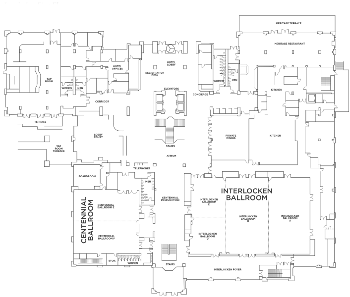
Interlocken First Floor
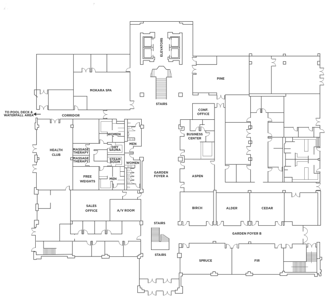
Interlocken Garden Level