GeoOptics CICERO Radio Occultation Excess Phase Processing at NOAA/STAR
Yong
Chen
NOAA/NESDIS/STAR
Poster
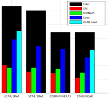
Radio occultation (RO) data provide high sensitivity and significant positive impact on the weather forecast, especially in the short-range 3-5 day forecast. Currently, the number of RO observation data assimilated into Numerical Weather Prediction (NWP) models is less than optimal; more RO data is required to improve the forecast. As one of the selected vendors from NOAA’s Commercial Weather Data Pilot (CWDP), GeoOptics operates its nanosatellites' constellation, known as CICERO-Community Initiative for Cellular Earth Remote Observation. CICERO carries advanced Global Navigation Satellite System Radio Occultation (GNSS-RO) sensors developed in partnership with the Jet Propulsion Laboratory (JPL) and Tyvak Nano-Satellite Systems. The first three CICERO satellites were launched in January, November, and December 2018, respectively. Under CWDP's first-round contract, NOAA received one-year GeoOptics near-real-time RO data generated by JPL from October 2018 to October 2019. NOAA recently received second-round one-month (from 15 December 2020 to 14 January 2021) GeoOptics RO data for Delivery Order-1 (DO), generated by University Corporation for Atmospheric Research (UCAR) operational data processing center.
While UCAR is the CICERO RO data processing center, the National Environmental Satellite, Data, and Information Service (NESDIS) Center for Satellite Applications and Research (STAR) is the RO data validation quality monitoring center in NOAA. To understand the CICERO data uncertainty induced in each RO processing step, STAR developed an independent processing package to convert the pseudo-range and carrier phase observations to excess phases. Understanding and characterizing the processing uncertainty before converting the observed phases to bending angle, refractivity, and atmospheric physical properties is essential to perform the validation and quality assessment. We will use the Bernese software to solve the LEO satellite clock bias and precise orbit determination (POD) and use the Radio Occultation Processing Package (ROPP) to convert these derived excess phases to bending angles. In this study, the comparison results for each step between our processing approach and those derived from UCAR for GeoOptics CICERO will be presented.
While UCAR is the CICERO RO data processing center, the National Environmental Satellite, Data, and Information Service (NESDIS) Center for Satellite Applications and Research (STAR) is the RO data validation quality monitoring center in NOAA. To understand the CICERO data uncertainty induced in each RO processing step, STAR developed an independent processing package to convert the pseudo-range and carrier phase observations to excess phases. Understanding and characterizing the processing uncertainty before converting the observed phases to bending angle, refractivity, and atmospheric physical properties is essential to perform the validation and quality assessment. We will use the Bernese software to solve the LEO satellite clock bias and precise orbit determination (POD) and use the Radio Occultation Processing Package (ROPP) to convert these derived excess phases to bending angles. In this study, the comparison results for each step between our processing approach and those derived from UCAR for GeoOptics CICERO will be presented.
Poster PDF
Meeting name
8th International Radio Occultation Working Group Meeting - IROWG-8