A new archive including radio occultation profiles collocated with the largest SO2 volcanic eruptions in between 2006 and 2016
Riccardo
Biondi
Università degli Studi di Padova, Dipartimento di Geoscienze, Padova, Italy
Poster
Explosive volcanic eruptions can generate ash and SO2 clouds reaching the stratosphere and dispersing on a global scale. These volcanic events are at the origin of many hazards such as aircraft engine damages, ash fallouts, acid rains, short-term climate changes and health threats. Monitoring volcanic clouds altitude and dispersion over time is thus of primary importance to mitigate these hazards. When it comes to global monitoring satellite techniques have proven to be the most efficient at tracking volcanic aerosols in the atmosphere. However, satellite data are scattered amongst the different institutes and agencies acquiring and processing them, and their retrieval is time-consuming.
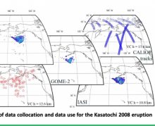
Here we present a multi-sensor archive collecting spatial and temporal information about volcanic SO2 clouds generated by the 11 largest eruptions in between 2006 and 2016. We archived and collocated the SO2 vertical column density estimations from three different satellite instruments (AIRS, IASI and GOME-2), the Global Navigation Satellite Systems (GNSS) Radio Occultations (RO), and the aerosol type from the Cloud-Aerosol Lidar with Orthogonal Polarization (CALIOP). We also provide information about the cloud-top height from three different algorithms including the bending angle anomaly due to the presence of the cloud. The dataset is gathering 206 days of SO2 data, collocated with 44180 backscatter profiles and 64764 radio occultation profiles.
This new archive allows an easy access to the datasets according to the users’ needs and its applications will impact many fields of volcanology and atmospheric physics, such as volcanic clouds dispersal numerical modelling and climate impact of volcanic aerosols. The data described here are published with a DOI at https://doi.org/10.5880/fidgeo.2020.016.
Poster PDF
Meeting name
8th International Radio Occultation Working Group Meeting - IROWG-8