The Viewer: Weather Data Visualized
CPAESS Associate Scientist, Christoper Ridener who works at NOAA’s Integrated Dissemination Program (IDP) has been busy perfecting the new version of the National Weather Service’s (NWS) GIS Viewer application, which is now live. This and many other NOAA products are created to serve the NWS mission of providing “weather, water and climate data, forecasts, warnings, and impact-based decision support services for the protection of life and property and enhancement of the national economy (NOAA).”
According to NOAA, “In July of 2021, the NWS began an experimental phase of an Experimental National Geographic Information System (GIS) Map Viewer (“the Viewer”) web application…[which] provides capabilities to display, interrogate, access, and discover data and easily assimilates this information so that those familiar with geospatial data and technology can seamlessly access and digest it. The Viewer’s data layers include everything from rapidly updating products (e.g radar) to more traditional products (e.g. forecasts), and from watches and warnings to reference boundaries.”
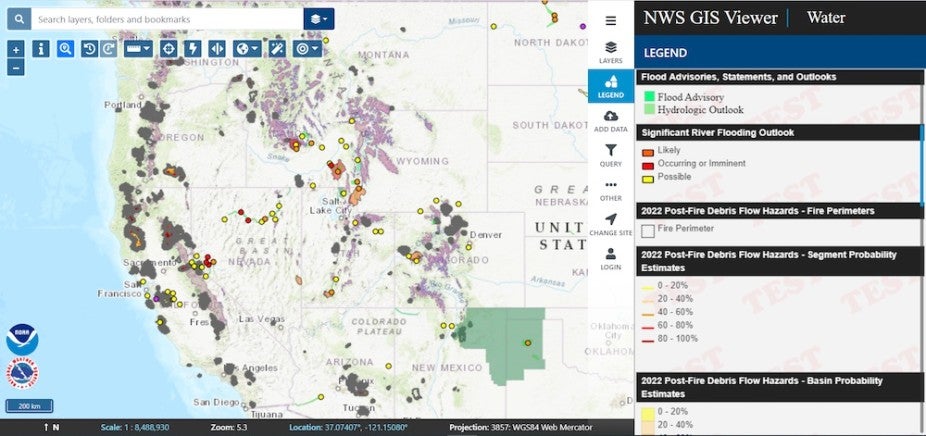
Screenshot of the NWS Viewer with many layers of GIS weather information available at one’s fingertips.
“[T]he Viewer now has a total of nine program sites accessible in the ‘Change Site’ menu. Work has begun to identify specific data to add to each of these sites. Tropical and Water have the most content at this time. Each of these program sites feature a collection of layers that are most relevant to that program. They include: Tropical, Water, Fire, Severe, Winter, Space, Climate, Aviation, and Marine. (NOAA).”

CPAESS Associate Scientist, Christoper Ridener
Christopher Ridener explained to us that “The new update included reconfiguring map feature layout, the addition of dynamic legends, and some bug fixes. We are continuously making/adding new datasets as they become available, or requested from NWS field staff.” When asked who would primarily be using this tool he shared that “The application is designed to be used by NOAA staff, emergency responders, and the general public, interested in visualizing weather data. It is a GIS application which hosts most U.S., federally-produced weather data, and makes it available for visualization and a small set of geoprocessing tools.”
NWS provides a plethora of information and tools for the public to use from emergency alerts, weather radio, educational information and so much more. The Viewer is an impressive and very robust tool that certainly adds to this library of information available to us all, and is definitely aiding NWS’ goal of creating a “weather ready nation.”
Ridener added “Since working in my current position with NWS, I have developed new insight as to what it takes to produce and maintain weather data on a federal scale. I have also gained new appreciation for the weather data I consume personally, knowing the process it takes to disseminate from the network of Weather Forecasting Offices, to my local news.” We are so glad you are on our team supporting NOAA’s critical public service goals. Thank you so much for sharing your work Christopher.