Correlation of Navigation Solution Parameters Affected by High-Latitude Ionospheric Scintillation Through Allsky Imagery
Mason
Bay
United States Military Academy
Poster
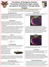
With the upcoming solar maximum, users may find themselves unable to navigate in high-latitude regions due to a higher likelihood of geomagnetic storm activity combined with the fewer high elevation satellites in view of high latitude receivers. Through analyzing data from high-resolution Connected Autonomous Space Environment Sensor (CASES) GPS receivers and simulations run on SkyDel Global Navigation Satellite System (GNSS) simulator, we have aimed to develop an index to categorize the severity of geomagnetic storms and the effects they have on the operational use of GPS receivers at higher latitudes. Our results are based on a geomagnetic storm on August 26th of 2018 as observed by a CASES receiver located at the Poker Flat Research Range.
The visible aurora is an obvious indicator of plasma-dense regions of the ionosphere. Plasmas contribute to the high total electron content (TEC) in the range between the receiver and the GPS satellite. This high TEC can cause delays in the reception of GPS signals, affecting the pseudorange measurement that the receiver calculates. Therefore, a relationship can be established between GPS pseudorange measurements and the discrete aurora found in AllSky imagery. This study's purpose is to visualize the real-time effects of GPS scintillation during dynamic auroral events. Currently, this research takes a simplified approach to understanding this relationship by focusing solely on the pseudorange offset due to ionospheric activity. The future of this research is to contextualize GPS scintillation in visible dynamic aurora that can be used in an operational impacts index.
The visible aurora is an obvious indicator of plasma-dense regions of the ionosphere. Plasmas contribute to the high total electron content (TEC) in the range between the receiver and the GPS satellite. This high TEC can cause delays in the reception of GPS signals, affecting the pseudorange measurement that the receiver calculates. Therefore, a relationship can be established between GPS pseudorange measurements and the discrete aurora found in AllSky imagery. This study's purpose is to visualize the real-time effects of GPS scintillation during dynamic auroral events. Currently, this research takes a simplified approach to understanding this relationship by focusing solely on the pseudorange offset due to ionospheric activity. The future of this research is to contextualize GPS scintillation in visible dynamic aurora that can be used in an operational impacts index.
Poster PDF
Poster session day
Poster location
26
Meeting homepage