Development of a Regional Ionospheric TEC Map for Indonesia
Asnawi
Husin
Space Science Center LAPAN Indonesia
Poster
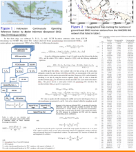
In this paper, a regional total electron content (TEC) mapping technique over Indonesia sectotr (85oE–150oE and 10o N 15o S) is developed on the basis of polynomial low order scheme driven by Global Navigation Satellite Systems (GNSS) data from the Indonesian Continuously Operating Reference Station (INACORS) network provided by the Indonesian Geospatial Information Agency (Badan Informasi Geospasial – BIG). The TEC data product GOTEC-LAPAN utilizes simple method of first order polynomial in order to build regional TEC map with spatial and temporal resolution 1∘×1∘ and 5 min, respectively. The accuracy and quality of the TEC mapping technique have been validated through cross comparison with individual GNSS station observations, the International Reference Ionosphere (IRI2016) model values and global ionosphere maps from IGS-GIM. The verification results indicate that the Mean Absolute Percentage Error (MAPE) of GoTEC-LAPAN model respect to IGS-GIM TEC is about 14.62 %, and that with respect to IRI2016 about 32.01%. To ensure the effectiveness of practical applications of the method asionospheric correction model, further testing of GOTEC-LAPAN output in the IONEX format is planned.
Poster PDF
Meeting name
8th International Radio Occultation Working Group Meeting - IROWG-8