50 Years of GOES XRS Science-Quality Data
James
Mothersbaugh III
University of Colorado Boulder Cooperative Institute for Research in Environmental Sciences (CIRES); NOAA National Centers for Environmental Information (NCEI)
Poster
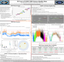
The X-Ray Sensor (XRS) instrument has flown on every Geostationary Operational Environmental Satellite (GOES) mission since GOES-1 launched in 1975. XRS measures solar irradiance in the X-ray region in 2 bandpasses, at 0.05-0.4 nm (short channel) and 0.1-0.8 nm (long channel). The GOES XRS data is used by the NOAA Space Weather Prediction Center (SWPC) to forecast the effects of space weather phenomena on Earth, and is also used by solar scientists to understand the statistics and dynamics of solar flares. This poster discusses science-quality data from GOES 1-18. The GOES 8-12 XRS science-quality data is complete. This reprocessing removes the incorrect “SWPC scaling factor” adjustment, sets data quality flags, and fills in data gaps, all of which have already been done for the science-quality GOES 13-18 data sets. In the last year, the average irradiance, daily background irradiance, flare summary, and flare detection products have been reprocessed and completed for GOES 8-12. Additionally, we present plans for completion of the GOES 1-7 XRS science-quality data, and the GOES 1-15 composite flare report product.
Poster PDF
Poster session day
Poster location
23
Meeting homepage