GOES Data Collection System RF Data as a Space Weather Data Source
Daniel
Gillies
NOAA / NESDIS / GEO
Poster
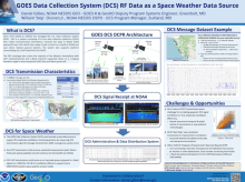
The GOES Data Collection System (DCS) is a NOAA operated radio frequency relay system which collects environmental data transmitted in the Ultrahigh Frequency (UHF) band by Data Collection Platforms (DCPs) across the western hemisphere. The GOES East and West spacecraft, collect the UHF transmissions and relays them via a bent-pipe architecture down to NOAA receiving stations in L-Band at Wallops Island, VA and Fairmont, WV. DCP transmissions have been known to experience suspected scintillation effects, particularly for South America sites, which to date have not been quantitatively characterized. Due to the large number (approximately 30,000 UHF DCP transmitters) and distribution (coverage ellipses down to 5 degrees elevation from GOES-East and West) of UHF transmitters and the geostationary nature of the bent-pipe relay, DCS may offer a unique opportunity to contribute a massive, open dataset that could be applied to HF scintillation topics relevant to space weather and aviation communities. Scintillation effects on DCS UHF transmissions may also serve as a closer proxy to scintillation effects on HF transmissions than the L-Band GNSS transmissions. This poster provides an overview of DCS, its geographic distribution, and technical characteristics to promote further discussion on the potential for use of this RF data within the space weather community.
Poster PDF
Poster session day
Poster location
15
Meeting homepage