Assimilating GNSS radio occultation observations improves hurricane forecasts
About 41 million people live in counties along the U.S. Atlantic coast, making them vulnerable to rapidly-developing hurricanes, one of the most devastating natural hazards. Pinning down a hurricane’s likely track and intensity are crucial to ensuring public safety.
New research published in the journal Weather and Forecasting indicates that assimilating Global Navigation Satellite System (GNSS) radio occultation (RO) observations in the Global Forecast System (GFS) and the Hurricane Analysis and Forecast System (HAFS), two numerical weather prediction (NWP) models, produces improved forecasts of hurricane track – improvements of up to 15-20% three-to-four days in advance.

Dr. Benjamin Johnston is a project scientist at the UCAR | Cooperative Programs for the Advancement of Earth System Science (CPAESS) in support of the NOAA Quantitative Observing System Assessment Program (QOSAP).
Credit: Benjamin Johnston
“Further, as more RO observations are assimilated into HAFS, it can result in improvements in metrics like hurricane maximum wind speed as well,” says Dr. Benjamin Johnston, lead author of the paper. Johnston is a project scientist at the UCAR | Cooperative Programs for the Advancement of Earth System Science (CPAESS) in support of the NOAA Quantitative Observing System Assessment Program (QOSAP).
The two NWP models are part of what is known as the NOAA Unified Forecast System (UFS), a framework for modelling Earth systems like short- and medium-range weather, air quality, and hurricanes. The GFS provides a structure or umbrella under which the high-resolution HAFS operates.
“It is important to note that HAFS uses global model output to initialize the model,” said Johnston. That is, GFS forecasts inform HAFS forecasts, and incorporating more RO observations into the GFS provides a more robust environment in which to run HAFS.
For the study, the team selected ten tropical cyclones from the 2022 Atlantic hurricane season – a near-average season – for inclusion, five of which made landfall over North America and Central America. Their classifications ranged from weak tropical storms to Category 5 on the Saffir-Simpson scale that classifies hurricanes based on maximum sustained wind speeds. Of those, Hurricane Ian’s maximum winds reached over 157 miles per hour, classifying it as a Category 5 hurricane. The tropical cyclones formed in different locations with varying tracks and durations.
It was important to analyze the impact of observations that provide adequate coverage over the oceans, where hurricanes form, and that can penetrate through cloud cover, two challenges that were resolved with the selection of GNSS-RO. GNSS-RO is a satellite remote sensing technique that utilizes signals from GNSS satellites to profile the Earth’s atmosphere with high accuracy and fine vertical resolution. (Source.)
Specialized instrumentation installed on various low-Earth orbiting satellites can receive these GNSS radio signals. As the signals traverse Earth’s atmosphere, they are refracted due to changes in atmospheric density at different altitudes and these refractivity measurements can then be used to derive temperature and water vapor in the atmosphere at various levels.
The authors ran an observing system experiment (OSE) using existing – or operationally available – RO observations so that they could compare forecasts in three different scenarios in which: 1) neither the GFS or HAFS forecast used RO observations (the control group), 2) the GFS used RO observations but not the HAFS, or 3) both the GFS and HAFS used RO observations. This approach allowed the research team to assess the accuracy of the forecasts based on the presence or absence of RO observations. There were up to ~9,000 globally-distributed RO profiles available for assimilation daily in scenario 2 and 3. Additionally, the team wanted to know which scenario would provide the biggest benefit to the set of tropical cyclone forecasts.
“When we did not modify the amount of RO observations assimilated in the global model, we didn’t see consistent impacts to track,” said Johnston. “But once we modified the amount of RO data assimilated in the global model, we started seeing considerable impacts to track forecasts and likewise to wind speed and intensity with the amount of RO data assimilated into HAFS.”
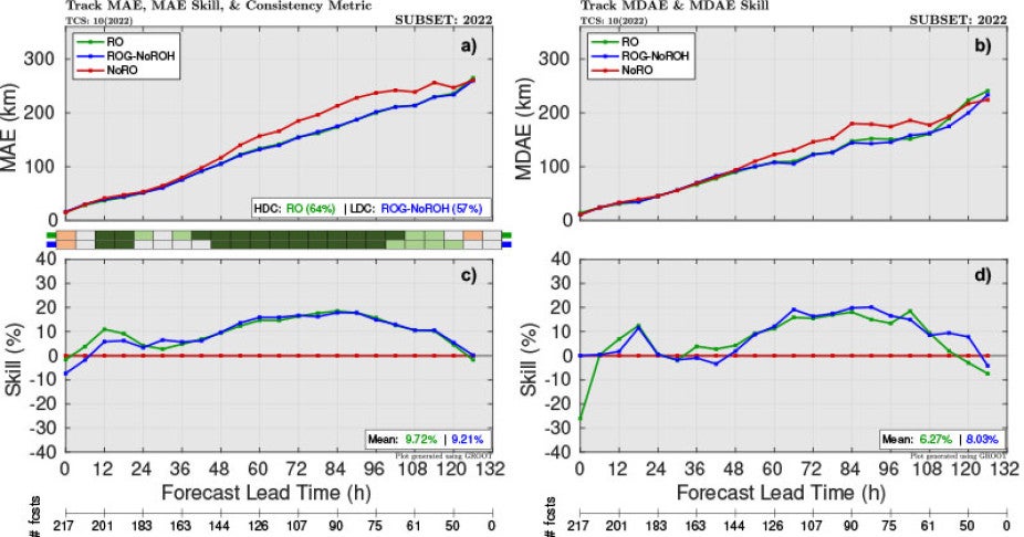
The impact of radio occultation observations on tropical cyclone track forecasts for the 10 tropical cyclones from the 2022 Atlantic hurricane season. Graphics include the (a,c) MAE and MAE skill, augmented with the consistency metric, and (b,d) MDAE and MDAE skill. The average skill relative to the control for each experiment across all lead times is given in the bottom right of the skill panels. The number of forecasts for each forecast lead time is shown at the bottom.
Credit: Benjamin Johnston
Previous observing system simulation experiments (OSSEs) have shown large improvements on many forecast metrics; however, unlike an OSE that uses real observations, these studies have used simulated data. An additional facet of Johnston’s study included an analysis of the impact of assimilating even more real observations on five hurricanes – up to 30,000 per day – by tapping into an archive of RO data collected during the Radio Occultation Modeling EXperiment (ROMEX). ROMEX is an international collaboration aimed at increasing the number of RO observations available to operational centers in order to test their impacts on model forecasts, like the GFS and HAFS. Through the ROMEX archive, Johnston gained access to three-to-four times as many daily observations than are typically available to operational centers for routine forecasts.
Adding the additional RO observations from ROMEX showed up to 25-30% improvements in tropical cyclone maximum wind speed forecasts, which was not seen in the first component of the project due to the smaller RO dataset. Assimilating the additional data for Hurricane Ian, for example, resulted in accurately forecasting its maximum wind speeds two-to-four days before landfall. The researchers concluded this was due to better representation of moisture measurements in the mid-troposphere.
In short, the results showed that tropical cyclone track forecasts are impacted primarily by the amount of RO data in the global model, whereas tropical cyclone intensity forecasts are controlled by the amount of RO data available for use in the hurricane model.
“The results of the study are promising,” notes Johnston. “Future work would ideally include multiple hurricane seasons to obtain a more robust sample of tropical cyclones along with more RO observations.”
This work was supported by NOAA
Watch Ben's CPAESS Discovery Seminar Recording "The Impact of Assimilating GNSS-RO Observations on HAFS Tropical Cyclone Forecasts from the 2022 Atlantic Hurricane Season"